Document 4½: Geometric Drawing of Two Parcels (30 Mar. 1799)
Explanation
Document 4½ is signed by Lieutenant Funck, a "beeidigter Landmesser" (sworn land surveyor). As a technical specialist, Funck was not part of the administrative offices (Amt) that issued Document 4. His report was therefore logged as an independent piece of correspondence, even though it accompanied document 4.
He completed his surveyor drawing over a year before it was enclosed in document 4. His drawing is dated March 30, 1799, but Document 4, which it supplemented, is dated over a year later, October 18, 1800. The survey wass probably submitted informally and used during negotiations, inspections, and back-and-forth between offices. earlier.
Transliteration and Translation
Transliteration of Diagram Text
| Position of Text | Transliteration |
|---|---|
Left side (angled boundary) |
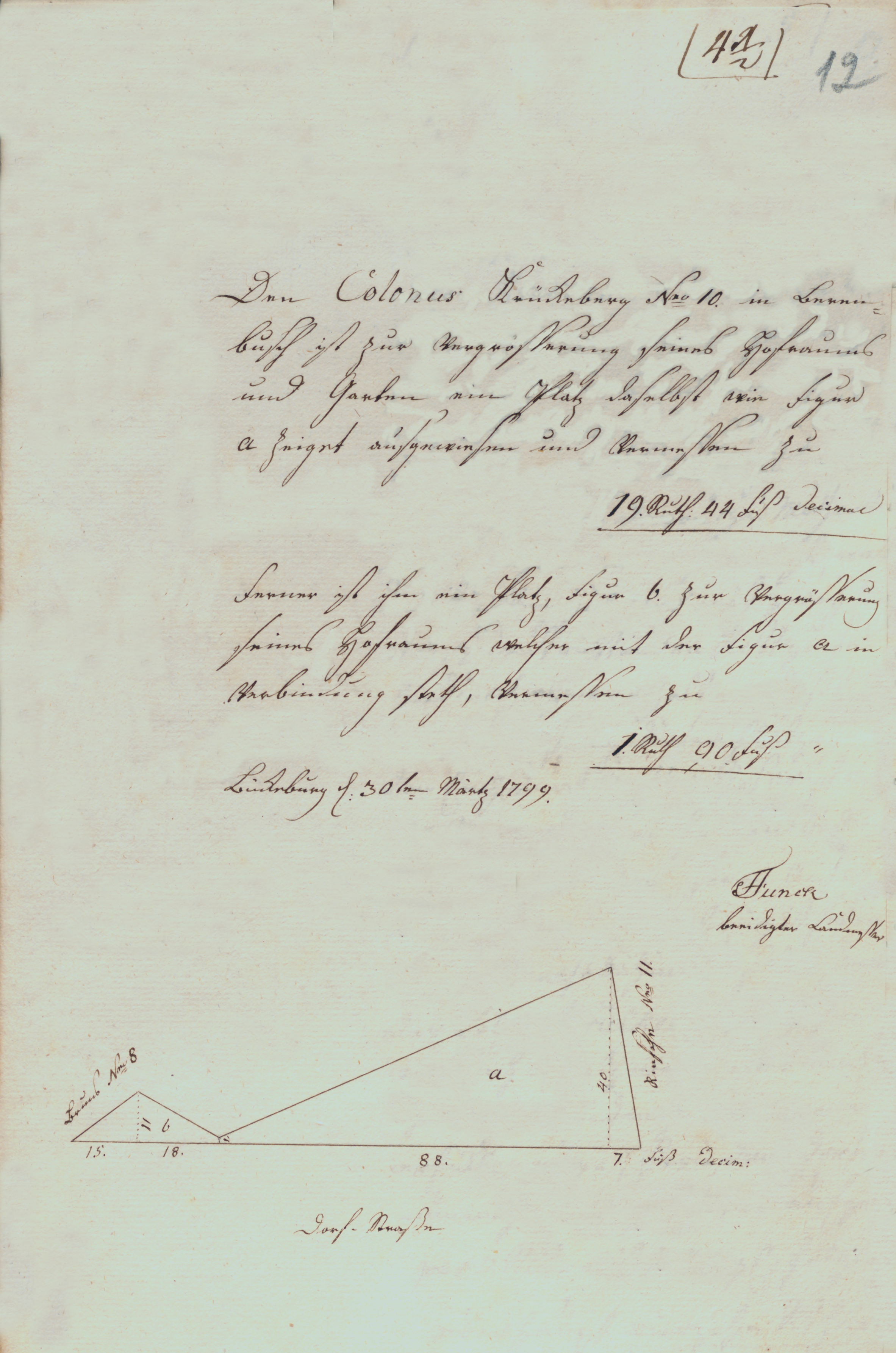
Bruns No 8 |
Right side (vertical label) |
Rinsehe No 11 |
Right side (horizontal, beneath vertical text) |
|
Below entire diagram (horizontal) |
Dorf Strasse (village street or drive) |
Main Text
Den Colonus Krückeberg Nro 10. in Beren- busch ist zur Vergrösserung
seines Hofraums und Gartens ein Platz daselbst wie Figur a zeiget[,]
ausgewiesen und vermessen zu

               19. Ruth: 44 Fuß Decimul

Ferner ist ihm ein Platz, Figur b,. zur Vergrösserung seines Hofraums[,]
welcher mit der Figur a in Verbindung stetht, vermessen zu

               1. Ruth 90 Fuß

Bückeburg d. 30ten Märtz 1799.

                        Funck
                        beeidigter Landmesser
To Colonus Krückeberg, No. 10, in Berenbusch, a plot has been assigned
and measured on the site for the enlargement of his yard and garden, as
shown in figure a, measuring

19 Ruthen, 44 feet, decimal.

Furthermore, a plot identified as figure b, for the enlargement of his
yard, which connects with figure a, has been measured at

1 Ruthe, 90 feet.

Bückeburg, the 30th of March 1799.

                     Funck
                sworn surveyor
The phrase "we make the proposal, without further negotiation, that he be assigned this land…" should be interpreted as:
"We propose — without entering into any further negotiation or discussion (particularly with Jobst Heinrich Krückeberg) — that the land be formally assigned to him…"
This reflects that the offices of Bückeburg and Arensburg were putting forward a definitive recommendation or decision to the Cammer (Chamber), expecting it to be accepted and implemented without need for further consultation with the petitioner.
Glossary of Terms
- Colonus
-
A hereditary leaseholder. In 18th–19th century German documents, "Colon" or "Colonus" was a formal title, not a personal name. One did not necessary have to be a farmer.
- Ruthe (plural: Ruthen)
-
A historical German unit of length or area. As a unit of area, 1 square Ruthe varied by region, but was typically between 3.5 and 4 square meters. In this context, it likely refers to square Ruthen.
- Fuß
-
German for “foot” (plural: Füße). A traditional unit of length, slightly shorter than the modern foot — usually around 28–30 cm depending on locale.
- decimal
-
Refers to the decimalized portion of a Ruthen or Fuß, used to express fractional values in land measurements. Example: “44 feet decimal” indicates a base unit plus fractional precision.
- Funck
-
The surname of the sworn surveyor who authored and signed the measurement report. Likely a local land surveyor or geometer active in Bückeburg around 1799.
- beeidigter Landmesser
-
Sworn surveyor — an officially appointed and sworn-in land measurer responsible for producing certified land plans and records.
- Verbindung
-
Connection or linkage — used to describe how figure b connects to figure a in the layout.